Visit Ischia

Italian - ItalyEnglish (United Kingdom)
You are here: Home

Tower of Via Morgera

email print

Description

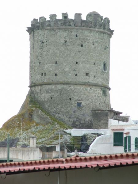
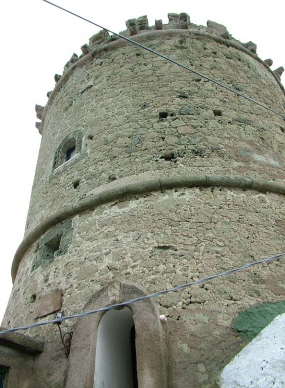
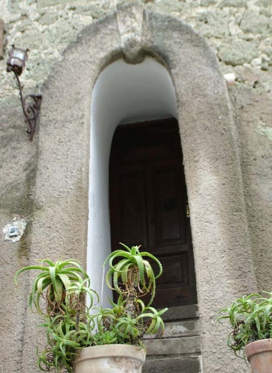
The tower has a square plant, a flat roof of two levels. The permanent structure is made of tuff stone, the corners are reinforced by shaped blocks. By two sides there are opening surrounded by trachytic stone. The tower reigns the built up are of Cierco, popular district of Forio, reachable by Via Roma. It was built with tuff stones and lava material. Nowadays deserted, private residence in the past, as windows crated only later, show. Going on up to the square of Cierco to the left, there is a small street that leads to the Tower of Vic Schiano.

Historic info

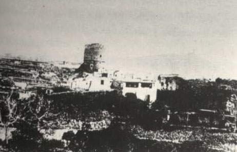
The intense Turkish invasions were the cause of the Towers building in Forio. The area of Cierco was suitable to host these structures for its streets, very small hard to pass across. The tower of Via Morgera, private property, offered refuge and defence to the inhabitants of the zone. Camouflaged among buildings, nowadays the tower is good hidden, also because of the many changes.
Mappa Torre di Via Morgera

Info

cadastre: f.17 n.448.
period: XVI sec..
destination:tower of defence
Property: private.
Lay out: square.
Roofing: plan.
Stairs:inside flight.
Permanent structure: tuff stone.
External decoration:lava stone.
Location: Cierco
Address: Via Morgera n. 94
Foundation: XVI
Date: 1500-1549
state of preservation: Mediocre

fotogalleryvideogallery

Torone

email print

Descrizione

Located a part the built up area, in a suggestive and panoramic position, the tower called Torone, represents an important visual point by sea and land. It was realized as place of refuge and defence against pirates attacks, nowadays is a private residence. The circular base, in fact, consists of a rocky block with an access realized in dug steps. A thick torus divides the roofing by the first level. A second torus repeats the covering, with consoles by its sides. To finish, a plan roofing with windows and slits of tuff stone. Retuirning to the centre, after Via San Vito toward Via Roma and Gaetano Morgera begins the ancient suburb called Cierco. After 100 meters to the right the Tower ‘Via G. Morgera’ rises.

Historic info

The tower is situated in a strategic position, between land and sea. The zone around was plan without natural refuges where people can lie low, so between 1534 and 1536, during pirate Dragut attacks, the tower of defence was built.
Mappa Torone

Info

Place: strada Torone, 11
Cadastre: foglio 22 part. 84.
Period: hal of the XVI sec.
Original use: tower of defence and refuge
Today's use: home
Property: private.
Protection law: n. 1497 del 193.
Plant: circular.
Roofing: plan-terrace style
Vault or roofs: emisphere-shaped vault.
Stairs: Stairs dug into tuff stone and wall.
Pavement: brick
External decorations: taurus and consoles in lava stone.
State of preservation: good

fotogalleryvideogallery

Milone Tower or San Vito tower

email print

Description

The tower is also called Milone or of Liviero. It's also known as the tower of St. Vito, the name of the street where it is set. Founded as a refuge and defense building, is now a private home. It has a square plan, with a ground floor, a mezzanine and first floor. It has a masonry of tufa stone, plastered faux rusticated ground floor and smooth the top. The final part presents a parapet containment.

Historical Info

Following the Turks’ raids who infested the forian coasts since 1558, as remembered by a document of the Royal Court, on 15/6/1567, 7 towers were erected by certain citizens, well-equipped with weapons in which people of that house can take refuge in case of the marauding Turks. "Among these is the tower Milo, to which was added in 700 the palace of the same name, built, therefore, to defend the mainly developed around the parish church of St. Vito (XIV) as can be seen from the incision shown on the title the book of G. Jasolino (1588).
A square, the tower grows in the ground floor, mezzanine and first floor. The tower of tufa stone, completely plastered in imitation ashlar ground floor flat on the top floor, is built around the vertical and facing the outside of a truncated pyramid up to the first bull of separation, upon which the shelf of the balcony.
The end has no crown and features a simple parapet containment.
Reached the square of the Basilica of San Vito is already possible to see the Torone. At the very beginning of Via degli Agrumi (at the end of Via San Vito and crossing with Via Chiena) on the right after a short flight of stairs in Basalt is the entrance of the Tower.
Mappa Torre Milone o di San Vito

Info

Place: via S. Vito.
chronology: second half of the sixteenth century.
Original use: tower of defense and refuge.
Today's use: home.
Property: private.
Protection laws: 1497 of 1939.
Lay out: square.
Roofing: terrazzo style.
Vaults or attics:: pavillion valut.
Stairs:: interior.
Masonry: masonry in tuff rock.
Floors:lapillus stones
external decorations: torus in lava stone.
State of preservation: good

fotogalleryvideogallery

Costantina Tower

email print

Description

At the heart of the medieval center of Forio, built on a rocky bank of tufa, stands the tower called "Constantine" built in the sixteenth century. A bulwark and defense against pirate raids of the homes that they switched around. It is currently used as a residence by individuals and was dwelling in the past, artists such as Lelo Fiaux. It has a circular shape with a flat terraced and once hemispherical. The walls are green tuff stone and the floor is beaten lapillus. Outside is decorated with two bulls in lava rock, the first time at the height of the hemispherical off the upper from the lower, while the second surrounds the cover. The tower is accessed through the adjacent garden, where rustic columns arranged along the avenue, supporting the pergola, by way 'of the lattice, the cylindrical frames. For the fall of the external plaster, at the base, you can clearly see the wall in stone, which, in the parts most exposed, shows signs of erosion caused by wind and sea salt. The floor is of beaten lapillus. The ring of the bull in lava rock, at the height of the attack once hemispherical off the floor, perfectly cylindrical, from the lower, slightly shoe, without frameworks. The roof of the tower is flat, surrounded by a second bull on which are grafted short shelves, remaining parts of the crowning cornice. Near the entrance on the right side, which is located a stone, however, is only visible emblem. Back on the road instead of going back further to the left until you reach the intersection with the road to San Vito. 150 meters. on the right just before the Basilica of St. Vitus is the tower of St. Vitus

Historical info

The guard tower, a circular plan, part of the first group of defensive buildings.
Mappa Torre Costantina

Info

Place:  via Costantina.
chronology: second half of the sixteenth century.
original destination: tower defense and refuge.
current destination: home.
Property: private (di Alfredo Ruggiero).
Leggi di tutela: n. 1497 del 1939.
Plan: circular.
Roof: plain to the terrace.
Vaults and roof:hemispheric vault.
Scale: in wood.
masonry techniques: stone masonry in green tuff.
Floor:in the lapillus chopped
external decorations: torus in lava stone.
State of preservation: good
Juridical condition: private property

fotogalleryvideogallery

Tower of Casa patalano

email print

Descrizione

The tower of Casa Patalano is located inside the most ancient area of Forio, set in a medieval suburb of narrow streets, characterize by continuous and sudden change of direction, to make hard the access of the enemy in case of Saracen invasions and at the same time offers advantage of defence because the narrow streets were easy to stop. It was built by a private citizen, like tower of defence and refuge, nowadays used as residence. It has a square, terrace and pavilion vaulted. Outside, the torus consists of lava stone on the ground floor. The upper floor has only one floor. The permanent structure is in tuff stone.
The tower was restructured in the early 20th century, the last two meters of masonry and covering roof show the intervention to add the lacking side.

Historic info

After the Turkish invasions, along the foriane coasts, documented by Regia Corte of 26/06/1567, the lack of fortification works to defend, also private citizens created towers in order to defend by these pirates. The tower of Via Patalano, realized in the end of the XVI century, was realized as residence and in case of danger, as refuge for the inhabitants, with windows by the square plant sides. The external and internal parameter, vertical, consists of tuff and rachitic rocks, reinforced by shaped blocks.
The stone tuff torus is collocated at the high pavilion vaulted roofing at the ground floor. The upper ground is covered by plan roof with access by the porch inside through stairs in open space, placed along three sides and supported by deep arches standing on pillars.
Going on toward Via S. Antonio Abate, to the right there is the church of S. Sebastiano Martire., while to the left after 50 m there is the Tower Costantina. Climbing a ladder you arrive to a small crossroad. Turning to the left there is the main entrance of the tower.
Mappa Torre Casa Patalano

Info

Period: end of XVI sec.
Original use: tower of defence and refuge.
Today's use: home
Property: private (by Calise Maddalena).
Protection laws: N. 1497 del 1939.
Plan: square.
Roofing: plain and terrace.
Vault or roofs:pavilion vaulted.
Stairs: internat fligjht of stairs
Masonry: tuff stone.
Pavement: lapillus
External decorations:taurus in lava stone
state of preservation: good
Property: private

fotogalleryvideogallery

Page 5 of 16

Il nostro sito Web utilizza i cookie. Utilizzando il nostro sito e accettando le condizioni della presente informativa, si acconsente all'utilizzo dei cookie in conformità ai termini e alle condizioni dell’informativa stessa. Per saperne di più sui cookie, visualizza la Privacy.

Accetto i cookie da questo sito.